Record revealed
Secret map of operations in North Burma
This map was provided to soldiers during the first operation by the Chindits, special forces serving in Japanese-occupied Burma in the Second World War.
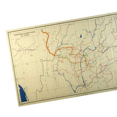
Image 1 of 2

The map in full
Image 2 of 2

Close-up of the map's key
Transcript
REFERENCE
RAILWAY SHOWING DEMOLITION
RIVER
BOUNDARY DEMARCATED
BOUNDARY UNDEMARCATED
SUPPLY DROPPING
AIR SUPPORT BOMBING
ENGAGEMENT
NATURAL LANDING GROUND
COLUMN ROUTES INTO BURMA
DISPERSAL ROUTES OUT OF BURMA
AIR LINK
Why this record matters
Date: 1943
Catalogue reference: CAB 106/46
In March 1942 the British colony of Burma (now Myanmar) fell to the Japanese military, forcing a 1,000-mile retreat of British forces to India. Months later the Chindits were formed, a multi-ethnic brigade comprised of British, Burmese, Nepalese, Indian and, in later operations, African soldiers. Their goal was to disrupt the enemy and to restore confidence that the seemingly invincible Japanese could be successfully combatted.
Maps were vital to Chindit operations, which were based on the idea of independent columns marching across the jungle and dispersing into smaller units to evade detection and capture.
In his report on the second Chindit operation in 1944, Michael Calvert, leader of the 142 Commando Company, criticised the inadequacy of the ½-inch maps that were most widely distributed to troops. He praised the ‘infinitely superior printing, paper and colourification’ of the Japanese maps, which were used by the British whenever they managed to get hold of them. He also regretted the lack of compasses, which he described as essential a part of a soldier’s equipment in the jungle as his boots.
The Operation Longcloth war diaries suggest that these problems were compounded by poor equipment and a lack of training in map reading and navigation. An Appendix to the war diary for the 13 King’s Regiment (Liverpool) describes how the luminous paint in the compasses often fell out of the grooves in the lid. An entry for 11 April 1943 records that the whole day was ‘completely wasted by inaccurate map reading’.