Record revealed
The first American invention to obtain an English patent
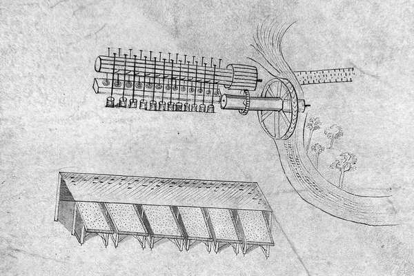
These intricate 1716 drawings were submitted by Sybilla Masters in the final stage of securing a patent for machinery for 'cleaning and curing Indian corn'.
Piece
Catalogue reference: MAF 1/924
This record is about the Enclosure award and map of Cefnllys [Llandegley Rhos] (parish), Radnorshire. Includes... dating from [1885] in the series Agriculture, Fisheries and Food Departments, and related bodies: Enclosure Awards. It is held at The National Archives, Kew.
No, this record is not available online. However, you can order a copy. Other ways to view it.
Yes, this record is held at The National Archives and is available to see in person. How to view it.
Enclosure award and map of Cefnllys [Llandegley Rhos] (parish), Radnorshire. Includes Hendy Bank Common. Map covers the enclosed area only (128 acres) and shows the land after enclosure. Also shows ford, stiles, field boundary ownership. A note on the face of the map reads: 'A privilege is reserved to the Public by the Inclosure Award of enjoying at all times, air, exercise, and recreation on all parts of the lands to be inclosed which shall be unplanted or uncultivated for arable purposes'. With border. Scale: 1 inch to 3 chains. By Copyhold, Enclosure and Tithe Commission, [1885]. Map certified for accuracy, 17 December 1885. Valuer: Stephen William Williams, Rhayader, Radnorshire, Land Surveyor
The county enrolled copy of this map is held at Powys County Archives Office, at reference R/QS/DE/16
MAF 1
See the series level description for more information about this record.
Enclosure award and map of Cefnllys [Llandegley Rhos] (parish), Radnorshire. Includes...
Read stories that share a catalogue subject with this record.
Record revealed
Record revealed
Record revealed
Records that share similar topics with this record.