Record revealed
The first American invention to obtain an English patent
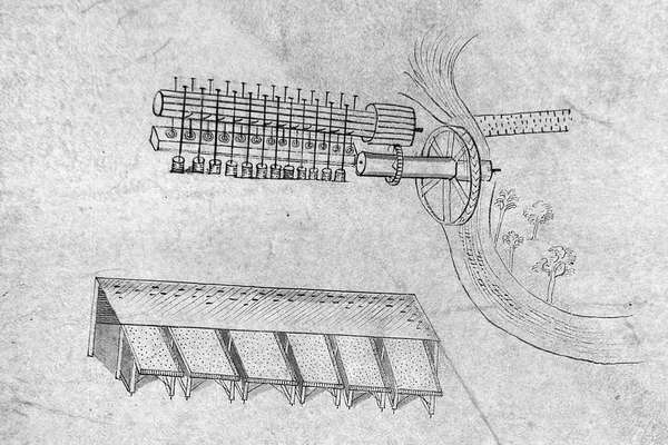
These intricate 1716 drawings were submitted by Sybilla Masters in the final stage of securing a patent for machinery for 'cleaning and curing Indian corn'.
Piece
Catalogue reference: MAF 1/332
This record is about the Enclosure award and map of Asthall, Whichwood and Fulbrook (parishes), Oxfordshire.... dating from 1860 in the series Agriculture, Fisheries and Food Departments, and related bodies: Enclosure Awards. It is held at The National Archives, Kew.
Sorry, information for accessing this record is currently unavailable online. Please try again later.
Enclosure award and map of Asthall, Whichwood and Fulbrook (parishes), Oxfordshire. Map on two sheets. Map A covers the enclosed area only (553 acres) and shows the land before and after enclosure. Also shows lakes or ponds, coppice, named commons, roads (some named), houses and uninhabited buildings (distinguished by colour), named inn, parish boundary, field boundary ownership. Includes a location diagram for a detached part. With border. Scale: 1 inch to 3 chains. Construction lines shown. By William Bryan Wood, Chippenham, 1860. Map certified for accuracy, 20 November 1862. Map B covers the enclosed area and some other land (1600 acres) and shows the land after enclosure. Also shows some houses. With border. Scale: 12 inches to 1 mile. By William Bryan Wood, Chippenham, 1860. Valuer: William Bryan Wood, Chippenham, Wiltshire, Land Surveyor. Dimensions of maps: Map A) 109 cm x 173 cm, Map B) 79 cm x 144 cm
The county enrolled copy of this map is held at Oxfordshire History Centre, at reference QSD/A, Vol 3
MAF 1
See the series level description for more information about this record.
Enclosure award and map of Asthall, Whichwood and Fulbrook (parishes), Oxfordshire....
Read stories that share a catalogue subject with this record.
Record revealed
Record revealed
Record revealed
Records that share similar topics with this record.