Record revealed
Request for compensation for the Boston Tea Party
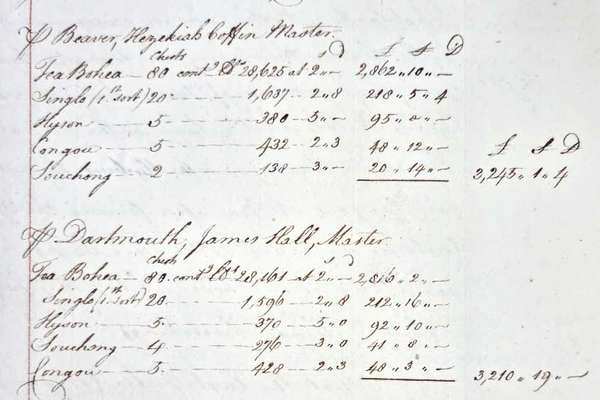
On 16 December 1773, 340 chests of tea were thrown into Boston harbour by protesting colonists. This letter from the East India Company requests reimbursement.
Series
Catalogue reference: IR 29
IR 29
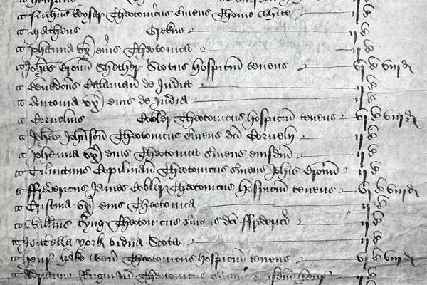
The Tithe Commutation Act 1836 aimed to change payments of tithe (a tax to support the church) from in-kind to money in the form of tithe rentcharge. These tithe apportionments were created to record liability to pay tithe rentcharge. 11,830...
The Tithe Commutation Act 1836 aimed to change payments of tithe (a tax to support the church) from in-kind to money in the form of tithe rentcharge. These tithe apportionments were created to record liability to pay tithe rentcharge. 11,830 tithe districts were apportioned and mapped: 10,871 in England and 959 in Wales. The apportionments generally set out the names of the holders and occupiers of land in each tithe district (usually a parish or township), the acreage and use of each parcel of land, the amount of tithe rentcharge payable and the names of the tithe owners. Until 1936, subsequent altered apportionments were added after the original apportionments.
The tithe apportionments are arranged by counties, firstly for England and then for Wales, named as they were at the beginning of Queen Victoria’s reign: Hampshire was listed as Southampton; Monmouthshire was at that point counted as an English rather than a Welsh county. Within each county, parishes are listed alphabetically. Parish names are those given on the tithe documents, with a modern place name in square brackets, where the name has changed.
Tithe files which contain correspondence of the Tithe Commission concerned with proceedings for the commutation of tithes are in: IR 18
Tithe maps were drawn to act as a graphic index to these tithe apportionments, and together form what was termed the Tithe Survey. The maps were separated for storage reasons, because they are usually larger than the apportionments: they are now in:
Tithe Commission and successors: Tithe Apportionments
Read stories that share a catalogue subject with this record.
Record revealed
Focus on

Record revealed
Records that share similar topics with this record.