Focus on
Smuggling gangs and coastal policing in 19th-century England

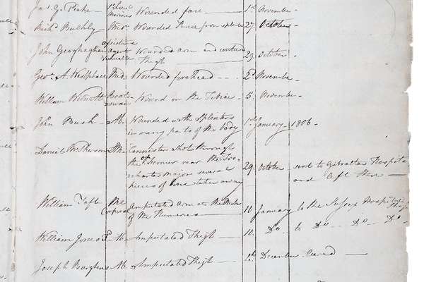
Following the Napoleonic Wars, smuggling became a major concern for the British government.
Piece
Catalogue reference: ZMAP 5/11
This record is about the ' A Chart of the Coast of Wales in St. George's Channel, drawn from and Actual Survey... dating from 1737-1744; 1748; ( 1985) in the series Facsimile Reproductions of Miscellaneous Maps and Charts. It is held at The National Archives, Kew.
No, this record is not available online. However, you can order a copy. Other ways to view it.
Yes, this record is held at The National Archives and is available to see in person. How to view it.
' A Chart of the Coast of Wales in St. George's Channel, drawn from and Actual Survey now lying at the Admiralty Office and made between the Years 1737 & 1744 by the Order and Encouragemnt of the Lords of the Admiralty. By Lewis Morris. Published by the author, 30 Sept 1748. Reproduction by National Library of Wales, (1985)
ZMAP 5
See the series level description for more information about this record.
' A Chart of the Coast of Wales in St. George's Channel, drawn from and Actual Survey...
Read stories that share a catalogue subject with this record.
Focus on
Record revealed

Record revealed
Records that share similar topics with this record.