Record revealed
Request for compensation for the Boston Tea Party
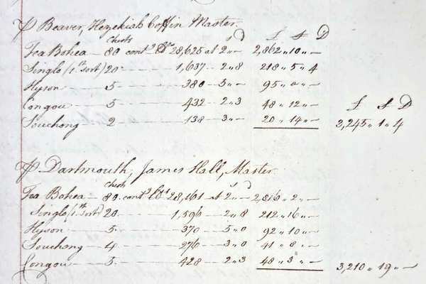
On 16 December 1773, 340 chests of tea were thrown into Boston harbour by protesting colonists. This letter from the East India Company requests reimbursement.
Piece
Catalogue reference: IR 30/17/366
This record is about the Tithe map of Teynham (parish), Kent. Shows buildings (named), glebe, Queen Anne's... dating from [1839] in the series Tithe Commission and Successors: Tithe Maps. It is held at The National Archives, Kew.
Yes, this record is available from a third party. Alternatively, you can view it online for free at The National Archives. How to view it.
No, this record is not available to see in person at The National Archives. Other ways to view it.
Tithe map of Teynham (parish), Kent. Shows buildings (named), glebe, Queen Anne's Bounty lands, footpath and/or bridleway, waterbodies. Some foreshore features depicted: high and low water marks. Colouring used. Scale: 1 inch to 3 chains. First class map. Construction lines shown. By Frederick and Henry E Drayson.
With 4 altered apportionment maps.1] Dated 25 July 1861, at 1 inch to 3 chains. 2] Dated 3 November 1871, at 1 inch to 3 chains. 3] Dated 3 January 1884, at 1 inch to 3 chains. 4] Dated 10 March 1913. Other altered apportionment maps are located with the apportionment.
Tithe file: IR 18/3834
Tithe apportionment:
IR 30
See the series level description for more information about this record.
Tithe map of Teynham (parish), Kent. Shows buildings (named), glebe, Queen Anne's...
Read stories that share a catalogue subject with this record.
Record revealed
Focus on

Record revealed
Records that share similar topics with this record.