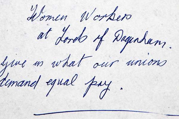
Focus on
Emily Capper and the 1934 Gresford Colliery disaster

Our records tell the story of Emily Capper's desperate campaign to recover the bodies of the victims, including that of her son.
Piece
Catalogue reference: IR 30/5/142
This record is about the Tithe map of Daresbury (township in the parish of Runcorn), Cheshire. Shows buildings... dating from 1844 in the series Tithe Commission and Successors: Tithe Maps. It is held at The National Archives, Kew.
Yes, this record is available from a third party. How to view it.
No, this record is not available to see in person at The National Archives. Other ways to view it.
Tithe map of Daresbury (township in the parish of Runcorn), Cheshire. Shows buildings (named), school, field gates, quarry, sand or stone pits, parkland, footpath and/or bridleway, demesne land boundary, woods, waterbodies. Private road and turnpike roads distinguished. Colouring used. Scale: 1 inch to 3 chains. By Henry White, Warrington; map was 'corrected from an original survey made by James Cowley in 1831'
Tithe file: IR 18/1
Tithe apportionment:
IR 30
See the series level description for more information about this record.
Tithe map of Daresbury (township in the parish of Runcorn), Cheshire. Shows buildings...
Read stories that share a catalogue subject with this record.
Focus on
The story of

Record revealed
Records that share similar topics with this record.