The story of
Britain’s youngest prisoner of war: John Giles Hipkin
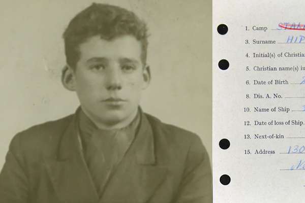
14-year-old cabin boy John Giles Hipkin became Britain's youngest Second World War prisoner of war in 1941 after he was captured at sea.
Piece
Catalogue reference: IR 30/2/37
This record is about the Tithe map of Clapcot and Queen's Arbour (liberty and extra-parochial district in... dating from 1837 in the series Tithe Commission and Successors: Tithe Maps. It is held at The National Archives, Kew.
Yes, this record is available from a third party. Alternatively, you can view it online for free at The National Archives. How to view it.
No, this record is not available to see in person at The National Archives. Other ways to view it.
Tithe map of Clapcot and Queen's Arbour (liberty and extra-parochial district in the parish of Wallingford, Allhallows), Berkshire. Shows buildings (named), infant school, keepers house, mill, field boundary ownership, area tithable to Dean and Chapter of Windsor, woods, plantations, orchards, marsh/bog, waterbodies, ferry, canal, towpath. Named roads; turnpike roads distinguished. Colouring used. Scale: 1 inch to 3 chains.
With 1 altered apportionment map
Tithe file: IR 18/13253
Tithe apportionment:
IR 30
See the series level description for more information about this record.
Tithe map of Clapcot and Queen's Arbour (liberty and extra-parochial district in...
Read stories that share a catalogue subject with this record.
The story of
The story of

Record revealed
Records that share similar topics with this record.